


MN : Tholonet toscan

ARPF
User
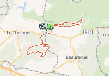

Length
9.9 km

Max alt
334 m

Uphill gradient
291 m
Km-Effort
13.8 km

Min alt
220 m

Downhill gradient
290 m
Boucle
Yes
Creation date :
2023-11-18 07:42:23.373
Updated on :
2023-11-18 10:16:15.011
1h57
Difficulty : Very easy

FREE GPS app for hiking
 SityTrail
IGN / Geographical institutes
SityTrail Plus
The world is yours!
About
Trail Nordic walking of 9.9 km to be discovered at Provence-Alpes-Côte d'Azur, Bouches-du-Rhône, Le Tholonet. This trail is proposed by ARPF.
Positioning
Country:
France
Region :
Provence-Alpes-Côte d'Azur
Department/Province :
Bouches-du-Rhône
Municipality :
Le Tholonet
Location:
Unknown
Start:(Dec)
Start:(UTM)
704258 ; 4821819 (31T) N.
Comments